


Products

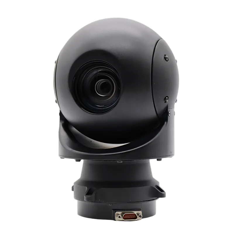
6KM Airborne 2 Axis Multi Sensors IR Electro Optics Systems
18 to 275mm zoom lens
Track mode
Target GPS
Less than 10kgs
Ground control system
Send Inquiry
Product Introduction
The 6KM Airborne 2-Axis Multi-Sensors IR Electro-Optics System is a lightweight and efficient solution designed for aerial surveillance and reconnaissance. It integrates infrared and electro-optical sensors, providing high-resolution imaging capabilities up to 6km detection range. With a 2-axis stabilization design, the system ensures smooth, stable image output during flight, even under dynamic conditions. Its compact structure makes it suitable for various UAV platforms, supporting real-time observation, tracking, and target positioning in both military and civil applications.
Equipment Rotation Performance Parameter Table
| Parameter Category | Index Item | Specific Parameter Requirements |
| Maximum Angular Velocity of Rotation | Azimuth | ≥60°/s |
| Pitch | ≥60°/s | |
| Maximum Angular Acceleration of Rotation | Azimuth | ≥100°/s² |
| Pitch | ≥60°/s² | |
| Rotation Range | Azimuth | 360° continuous rotation, left as negative and right as positive |
| Angle Reporting Accuracy & Resolution | - | Resolution: ≤1 mrad (milliradian) |
| Stable Accuracy | - | ≤0.1 mrad (milliradian) |
6KM Airborne 2 Axis Multi Sensors IR Electro Optics Systems Features
- Independent Core Infrared Detector
Equipped with an independently developed and proprietary core infrared detector, the system ensures reliability and advancement.
- Multi-band Real-time Output
Supports simultaneous real-time output of thermal and visible light images, enabling all-weather, multi-dimensional monitoring capabilities.
- Multi-functional Imaging Control
Built-in inertial image stabilization, target lock, and scanning functions enhance target tracking and monitoring flexibility.
- Precise Target Positioning
Utilizing the onboard information processing platform, the system enables rapid target identification and precise positioning, providing strong support for mission execution.
Product Application

UAV Aerial Reconnaissance

Land and Sea Target Search

Emergency and Rescue Operations

Environmental and Resource Monitoring
FAQ
Q: How is image stability guaranteed during flight?
A: The system utilizes a dual-axis stabilized platform and inertial image stabilization technology, ensuring clear images even under vibration and in complex environments.
Q: Is the data transmission method flexible?
A: The system supports both wired and wireless transmission, enabling real-time transmission of images and positioning information to a ground station based on mission requirements.
Q: Is the system's weight and size suitable for mounting on small drones?
A: The device's lightweight and compact design makes it ideal for small drones and light aircraft without compromising flight performance.
Q: What level of image clarity and resolution can be achieved?
A: The system is equipped with high-resolution infrared and electro-optical sensors, delivering high-definition images with crisp details, enabling rapid target identification.
Hot Tags: 6km airborne 2 axis multi sensors ir electro optics systems, China 6km airborne 2 axis multi sensors ir electro optics systems manufacturers, suppliers, factory
Send Inquiry
You Might Also Like
-
![Compact Airborne Multi Sensors EO IR Systems With Spherical Stabilization Platform]() Compact Airborne Multi Sensors EO IR Systems With Spheric...view more>
Compact Airborne Multi Sensors EO IR Systems With Spheric...view more> -
![Airborne 4 Axis Multi Band Reconnaissance Pod With Spherical Platform]() Airborne 4 Axis Multi Band Reconnaissance Pod With Spheri...view more>
Airborne 4 Axis Multi Band Reconnaissance Pod With Spheri...view more> -
![Long Range Cooled MWIR Online Monitoring Camera]() Long Range Cooled MWIR Online Monitoring Cameraview more>
Long Range Cooled MWIR Online Monitoring Cameraview more> -
![10KM Airborne 2 Axis Multi Sensors EO IR Systems For Small UAV]() 10KM Airborne 2 Axis Multi Sensors EO IR Systems For Smal...view more>
10KM Airborne 2 Axis Multi Sensors EO IR Systems For Smal...view more> -
![Airborne Payload EO IR Sensors Infrared Camera Gimbal System]() Airborne Payload EO IR Sensors Infrared Camera Gimbal Systemview more>
Airborne Payload EO IR Sensors Infrared Camera Gimbal Systemview more> -
![EO IR Gimbal Payload Dual Sensor Tracking System]() EO IR Gimbal Payload Dual Sensor Tracking Systemview more>
EO IR Gimbal Payload Dual Sensor Tracking Systemview more>


